How to Make a City Map for Your Novel
A city in a novel is not a backdrop. It is the thing that decides how long the walk home takes, which bridge the chase has to cross, and why your heroine never goes east of the river after dark. You do not need to be an urban planner or an artist to map one. You need to know what the city is for, where the water is, and which streets your scenes actually use. Here is how to plan it, and a map maker that hands you real streets to build on.
Start with what the city is for
Before a single street, decide what the city does in your story. A port city is about arrivals, cargo and people who are not from here. A capital is about power and who is close to it. A mill town is about one employer and the people who owe it everything. A university town is about the young, the old and the gap between them. Write one sentence: this city exists because of the river crossing, and everyone in it is either moving goods or taxing them. That sentence will settle a dozen later decisions for you, from where the money lives to where the fights happen.
Put the water down first
Almost every real city grew where there was water: a river to cross or sail, a harbor to shelter ships, a spring on a hill. So map the water before anything else. A river splits a city into two banks with two personalities, and every bridge becomes a place where people meet, wait, get stopped or get lost. A harbor gives you docks, warehouses, sailors' bars and a waterfront that smells different from the rest of town. Canals make a city slow and secretive. If your city has no water at all, decide why: a desert caravan stop, a hill fort, a city that pumps its water up from deep wells and guards them.
Old town and new town
Cities grow outward in rings, and you can read their age in the street plan. The oldest part sits closest to the reason the city exists, by the crossing or the harbor or the castle hill, and its streets are narrow, crooked and full of dead ends, because they grew one house at a time. Where the old walls stood there is often a ring road or a line of boulevards. Beyond that come the planned parts: straighter streets, a grid, bigger blocks, wider avenues. Further out still, newer housing, the station, the stadium and the places that need room.
This gives you texture for free. A character who grew up in the old town knows shortcuts nobody else does. A chase that leaves the grid for the old town gets slower and stranger. A newcomer who lives in the new town finds the old quarter beautiful and a little hostile.
Give each district a job
Three to five districts is plenty for most novels. Give each one a job, a mood and a reason a character would or would not go there. The market district is loud, crowded and good for being anonymous. The government quarter is wide, clean and watched. The docks are rough after dark. The hill is where the money lives, and the money likes a view. The district nobody from the hill visits is where your story probably wants to be.
Write the job of each district on the map itself. When a scene needs a place, you will know which district it belongs in, and the scene inherits that district's mood without you having to describe it again.
Where your characters live and work
Place three things for each main character: where they sleep, where they work, and where they go when they want to be alone. Then look at the distances. A detective who lives across the river from the precinct crosses a bridge twice a day, and that bridge can be the place where she always calls her sister. Two characters who live on the same street will run into each other. A character whose home and work are in different districts lives a double life whether you planned it or not.
Distance is also money and class. Who can afford to live near the center? Who commutes in from the edge? Who has never been to the other side of the river? A city map makes these things visible, and visible things turn into plot.
Trace the routes your scenes travel
Most of the city you map will only ever appear as a route: the walk home, the drive to the meeting, the run from the warehouse to the station. Trace those routes on the map. Note what they pass, and where they have to cross water, climb a hill or squeeze through a gate. Those choke points are where things happen: a bridge is where someone can be waiting, a station is where a crowd hides a meeting, a long straight avenue is where you cannot lose a tail.
Keep the timing honest. People walk about three miles an hour, so a mile across town is about twenty minutes on foot, longer uphill or through a crowded old town. If your character crosses the whole city in a paragraph, check that a map would agree.
A real city, or an invented one?
A real city brings readers who already love it, and the pleasure of recognition when you get a corner exactly right. It also brings readers who will write to you when the café you set a scene in closed in 2019, or when your one-way street runs the wrong way. If you set a book in a real city, walk it if you can, use a real map, and decide early how much you are willing to invent.
An invented city gives you freedom: the district you need, the crime you cannot set on a real street, the fantasy capital that has never existed. The risk is that invented streets come out too tidy or too random, because real cities are shaped by rivers, hills and centuries of decisions that are hard to fake.
There is a middle path, and it is how many writers work: borrow the shape of a real street plan, the way a real old town bends around its river, and fill it with your own names, landmarks and people. The streets feel lived in, because they were. Everything on the finished map is yours.
Name streets the way cities do
Real street names are small history lessons. They say where the street goes (Harbor Road, the Mill Lane), what used to be there (Tanners Row, Hay Market, Gallows Hill), who someone wanted to honor (a saint, a king, a general), or what the ground is like (Steep Street, Bridge End, the Narrows). Old names outlive their reasons: there is no hay in Hay Market anymore, and that is exactly why it sounds real.
Name sparingly. Name the streets your characters live on, the ones your scenes use, and a few big ones for orientation. Leave the rest blank. And keep a list, because a street that is Copper Lane in chapter three and Copper Street in chapter twenty is the kind of slip readers notice.
How Inkling's city maps work
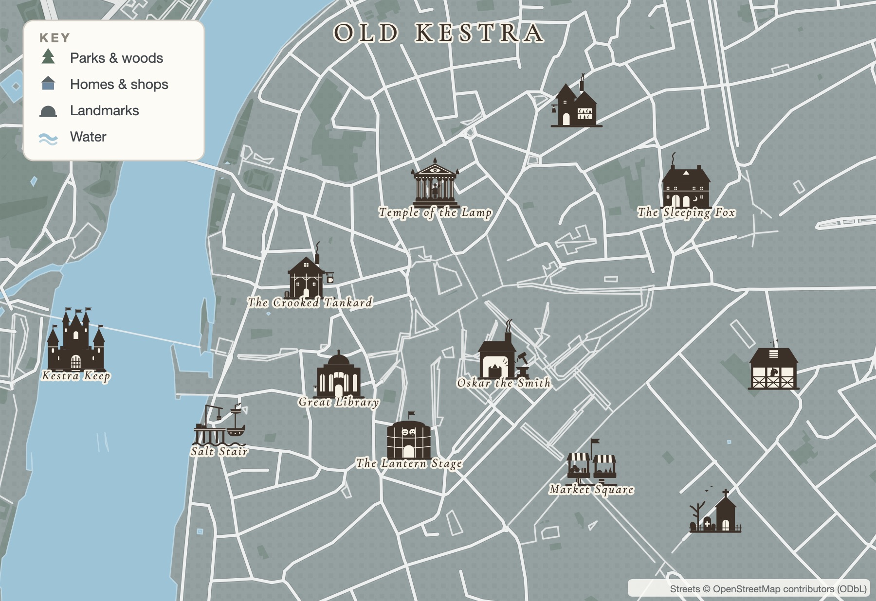
Inkling has a map maker built into the same desk as your draft, and it makes city maps as well as world maps. Each city layout starts from the real street plan of a real city: its streets, water and parks, from OpenStreetMap data (credited in the corner of the map). Every real name is removed, and the whole city is redrawn in Inkling's own style, quiet grey streets and buildings so that the places you add, drawn in color, are the first thing anyone sees. Twelve street plans are in the picker, each with a short note about its shape so you can choose by feel:
- Old town on a river, on the streets of Prague: bridges and a castle hill.
- Canal city, on the streets of Amsterdam: rings of canals.
- Hill town, on the streets of Lisbon: steep lanes and stairways.
- Grid city, on the streets of Manhattan: avenues and cross streets.
- With a Map Pass, eight more: a city on a ridge (Edinburgh), a city of water (Venice), a walled medina (Marrakesh), a dense quarter (Tokyo), a river capital (Paris), a temple grid (Kyoto), a ringed old town (Bruges) and an ancient heart (Rome).
Each one opens on a quarter of the city, and one tap switches to the whole city on the same streets, with everything you placed moving along with the ground. Would you rather not choose? Describe your city in a sentence instead, say a harbor town with a ferry, a fish market and a trattoria, and Inkling picks a street plan that suits it and places the spots you named on real blocks.
Today, or a fantasy town
City maps start in today's world, with stamps for the places a modern story needs, grouped the way you think about a city: eat, drink and shop (restaurants, cafés, bars, bakeries, markets, hotels); civic buildings and landmarks (city hall, the courthouse, a museum, a library, a theater, a church, a stadium); schools, sport and play (a school, a university, a sports field, a baseball diamond, a playground, a pool); homes, offices and parks; and getting around (a bridge, the train station, the metro, an airport, the harbor). A sports field or a pool looks for a block with room for it, so it lands on open ground instead of on top of a row of houses.
Writing something older? Flip the Fantasy town switch and the same streets become a town of taverns, inns, a smithy, a temple and a keep. Landmarks with a counterpart swap across on their own: city hall becomes a manor, the bar becomes a tavern, the church becomes a temple. Undo swaps them back.
Districts, streets and names
Everything in this guide has a tool. Outline a district by dragging a loop, and it closes and tints itself. Paint a park, a pond or an open square. Draw a new street, lane or canal where your story needs one. Then name things: a district name in spaced capitals across its area, a street name in italics along the way, or a little enamel street sign on a post with the name on the plate. Every stamp is drawn in one bold style, so the map reads like one place.
Styles, downloads and the rest of your world
Switch the whole map between Inkling Wash and Copperplate, and with a Map Pass, Gilded Night, ink blue paper with cream line and gold. If your story also has a world map, a Map Pass lets you double-click any town on it to open that town's own city map, already named and linked back. And because your maps sit on the same desk as your draft, your characters and your storyboard, you can press Write a story here on a kept map to start a new story with the places you named already in its notes.
You can start free: keep two maps and download two pictures, which carry a small Inkling credit, with no card. A Map Pass is $29 a year (or $4 a month) and keeps every map, gives you unlimited downloads with no credit, print and poster sizes and SVG files, all twelve cities, every layout, Gilded Night, and towns that open into their own city map.
Making the wider world too? Our guide on how to make a fantasy map covers the realm around your city, and where rivers, mountains and forests go covers the geography that decides where a city like yours would grow in the first place.
A few questions, answered
How do I make a city map for my novel if I cannot draw?
Start from a street plan instead of a blank page. Inkling's map maker builds city maps on the real street plans of twelve cities, with every real name removed and the streets drawn in its own style, so you only decide what goes where: the districts, the landmarks, the homes of your characters, and the names. Stamps for cafés, schools, stations, taverns and keeps drop onto the map in one click.
Should my novel use a real city or an invented one?
Use a real city when the real place is part of the story's appeal and you can get the details right, or are willing to be corrected by readers who live there. Invent one when you need freedom: a district that does not exist, a crime that would be awkward to set on a real street, or a fantasy world. A middle path is to borrow the shape of a real street plan and fill it with your own names and places.
How big should a city map for a novel be?
Big enough to hold every place your scenes visit, and not much bigger. Most stories live in a quarter of a city: a few districts, a river or a harbor, the home, the workplace and the places of trouble. Map that quarter in detail and leave the rest as streets. Inkling lets you switch between a quarter and the whole city of the same street plan, and your places move with the ground.
How do I name streets in a fictional city?
Name them the way real streets got their names: after where they lead (Harbor Road), what used to be there (Tanners Row, Old Market), a person or saint, or a feature of the ground (Steep Street, Bridge End). Old names survive long after the reason is gone, which is a quiet way to suggest history. Name only the streets your scenes use, and keep a list so the spelling never drifts.
Are Inkling's city maps based on real places?
Yes. Each city layout starts from the real streets, water and parks of a real city, from OpenStreetMap, credited on the map. Every real name is removed and the whole map is redrawn in Inkling's style, so the streets feel lived in and every name on the finished map is one you chose.
All of it. In one place.
This isn't five apps stitched together. Your storyboard, your cast, your maps, your covers, and the story itself all live on one desk, right beside the words. Nothing to sync between tools. No five separate subscriptions. Just everything a writer needs, finally in the same place.